Epic Road Trips in Bolivia: Salt Flats, Andean Passes & Amazon Detours
From salar sunsets to jungle detours, discover Bolivia’s most thrilling road routes — plus seasonal windows, 4x4 tips, safety intel, and soulful stays.
Mood
Overland Odyssey
At dusk on the Salar de Uyuni, the horizon dissolves. Headlights draw pale strokes across a polished sky-mirror; the tire crunch fades to a hush as flamingos lift from a distant lagoon. For travelers plotting exciting road trips in Bolivia, this is the promise: landscapes that unspool from volcano-crowned deserts to jungle-cloaked river basins, stitched together by mountain passes where engines thin in the altitude and stars feel close enough to pluck from the dark.
The Best Road Trips in Bolivia
Few countries deliver such variety per mile. The following routes capture the country’s drama and depth — from high-altitude circuits ducking past geysers and flamingo lagoons to cloud-forest descents and colonial towns where time seems to idle on sunlit plazas.

Lonely Planet Bolivia (Travel Guide): Albiston, Isabel, Grosberg, Michael, Johanson, Mark
Lonely Planet's Boliviais <strong>your passport to the most relevant, up-to-date advice on what to see and skip, and what hidden discoveries await you</strong>. Explore the world's largest s
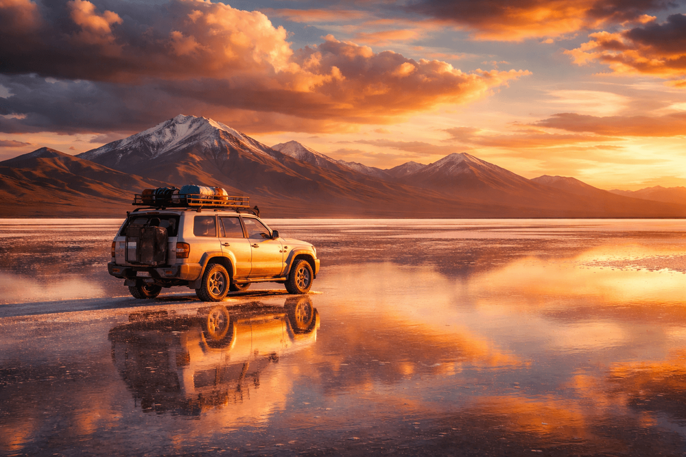
Check Price on AmazonUyuni and the Sur Lípez Loop: Salt, Lagoons & Geysers (4–5 days)
Why it’s special: The classic altiplano epic. Begin in Uyuni or Colchani and sweep across the world’s largest salt flat to cactus-studded Isla Incahuasi and the foot of the ochre-hued Tunupa Volcano. Beyond the salar, rough tracks nose into the Eduardo Avaroa Andean Fauna Reserve: a dreamscape of wind-sculpted rock, the steaming Sol de Mañana geyser field, and the painterly Red and Green Lagoons thick with Andean and James’s flamingos.
Signature moments & detours:
- Sunset and stargazing on the salar when the sky becomes a luminous dome reflected under your wheels. In the wet season (roughly January–March), the flooded flats create the famed mirror; in the dry months, drive the hexagonal salt crust to Isla Incahuasi for sunrise.
- Soak at the Polques hot springs, with volcanoes for company. Climb the edge of Tunupa for a condor’s-eye view of the salar. Stop at the eerie “Árbol de Piedra” rock formation and detour to the Salvador Dalí Desert.
Road notes: A high-clearance 4x4 is essential. Routes here are unpaved, waymarks can be cryptic, and conditions swing with weather. Travel in daylight, carry extra fuel and water, and consider a second vehicle or a local guide for deeper Sur Lípez tracks. Many travelers pair self-drive days with a guided segment or private driver; those craving indulgence can explore private salar picnics and salt-flat glamping via select operators featured in Luxury Bolivia: Bespoke Lodges, Private Salar Tours & Exclusive Andean Experiences.
Where to stay: The Palacio de Sal (booking-url) occupies a sculpted salt complex on the salar’s edge; its amber-lit dining room and horizon-to-horizon views justify every penny.
La Paz to Coroico: The Yungas Descent (1–3 days)
Why it’s special: A kinetic plunge from the Andean roof to citrus-scented cloud forest. From La Paz, crest the La Cumbre pass at 4,650 meters, where frost smokes off the roadside ichu grass, then descend nearly 3 vertical kilometers toward Coroico’s banana groves and coffee farms. Two routes exist: the modern paved highway (safer, faster) and the infamous Old Yungas “Death Road,” a ledge carved into rainforest cliffs with waterfalls threading across it.
Signature moments & detours:
- Pause at La Cumbre for views over glacier-scored peaks. As the air warms, watch for cock-of-the-rock birds and emerald toucanets dancing through the canopy.
- In Coroico, linger by orange-blossom-scented patios and visit organic coffee and cacao projects. Senda Verde Wildlife Sanctuary offers guided visits that support animal rescue.
Road notes: Only highly experienced drivers with local knowledge should tackle Death Road by vehicle; many choose to experience it safely by guided mountain bike while someone else handles logistics. Otherwise, take the new highway down and explore the old road on foot in short, scenic stretches. Overnight at the hilltop Hotel Gloria Coroico (booking-url), where sunset spills across the Yungas like melted copper.
Potosí–Sucre–Tarija: Silver, White Walls & Wine Valleys (4–7 days)
Why it’s special: A cultural arc through colonial grandeur to the country’s southern vineyards. Start in Potosí, once the beating heart of Spanish silver, where the honeyed stone of San Lorenzo Church glows at golden hour. Drift to Sucre, the “White City,” all tiled courtyards and jacaranda shade, then press south through the Cinti Valley’s crimson canyons to Tarija’s mellow plazas and high-altitude wineries crafting singani and crisp torrontés.
Signature moments & detours:
- In Sucre, trace the frescoed cloisters and climb La Recoleta for an ochre-roofed panorama. Families and gourmands can time markets for humintas hot from the steamer.
- Southbound, pause in Camargo’s vineyards for a bodega visit. In Tarija, meander the Ruta del Vino, sampling singani in sun-soaked patios as condors wheel on thermals above.
Road notes: Paved roads predominate, making this one of the more approachable road trips in Bolivia for standard vehicles. Still, allow extra time; Andean highways swing through switchbacks and speed humps watch over village entries. In Sucre, the Parador Santa María La Real (booking-url) unfurls around a restored colonial mansion — its rooftop terraces frame bell towers and blue hills beyond.
Sajama & the Altiplano Volcano Route (2–4 days)
Why it’s special: An otherworldly corridor of snow pyramids and pampas where vicuñas needle across cinnamon plains. Sajama National Park, anchoring the west near the Chilean border, is crowned by sacred Mt. Sajama (6,542 m) and girded with steaming hot springs, stands of giant queñua trees, and ancient chullpa funerary towers. The approach via Patacamaya and Curahuara de Carangas reveals tiny Aymara villages and a painted Baroque church with Andean frescoes.
Signature moments & detours:
- Sink into open-air springs as volcanoes blush pink at dawn. Wander among puya raimondii, the world’s tallest bromeliads, and spot rheas ghosting across the pumice flats.
- With a guide, detour toward the high Tambo Quemado pass or lesser-known viewpoints where Andean foxes watch from a polite distance.
Road notes: High altitude, frigid nights, and gravel tracks demand a 4x4, plenty of layers, and conservative pacing. For travelers interested in thermal soaks and high-altitude calm, the region pairs well with ideas in Bolivia Wellness Retreats: Top Resorts for Hot Springs, Andean Healing & Altitude Calm.
Santa Cruz to Samaipata & Amboró (2–4 days)
Why it’s special: A sensual transition from tropical city bustle to pine-fringed foothills and prehistoric ruins. Roll west from Santa Cruz through citrus farms and red-earth cutbanks to the cobbled lanes of Samaipata, gateway to Amboró National Park’s fern forests and cloud-shawled ridges. Above town, the UNESCO-listed El Fuerte — a sandstone monolith incised with ritual carvings — guards the valley.
Signature moments & detours:
- Hike to condor lookouts where shadows drape the ridgeline. Cool off beneath Las Cuevas waterfalls, a russet amphitheater brushed by aquamarine pools.
- Sample Andean-fusion plates on Samaipata’s leafy square, then bed down at El Pueblito Resort (booking-url), a storybook hamlet of whitewashed cottages stepping down a hill with fireplace-warmed rooms.
Road notes: Paved and graded roads make this an excellent first foray. In the rainy season, some park access tracks muddy; check locally before venturing to remote trailheads.
La Paz to Rurrenabaque: Gateway to the Amazon (2 days by road; or fly)
Why it’s special: A grand Andean-to-Amazon transect culminating on the Beni River. From the altiplano, drop through Caranavi’s coffee country to the river town of Rurrenabaque, springboard to Madidi National Park and the pampas of the Yacuma.
Signature moments & detours:
- Wake to howler monkeys and dawn mist on a pampas boat ride; track giant river otters and capybaras as jacanas step lightly on lily pads.
- In Madidi, guided walks with community-led lodges layer biodiversity with Indigenous knowledge — night hikes fizz with fireflies.
Road notes: The road is scenic but can be grueling, with landslides and closures in the wet season (December–April). If timing is tight or rains are heavy, fly from La Paz (about 40 minutes) and rent locally for short, scenic drives. Those who do drive should plan a 4x4, start early, and call ahead to confirm conditions.
Cochabamba to Torotoro National Park: Canyons, Caves & Dinosaur Tracks (2–3 days)
Why it’s special: A limestone labyrinth scrolled with prehistory. Torotoro’s canyons plunge in clean cuts; caverns bristle with stalactites; and dinosaur footprints stride across tilted slabs.
Signature moments & detours:
- Peer into El Vergel waterfall’s ferny bowl. Creep through Umajalanta Cave with a local guide’s lamp throwing cathedrals of shadow.
- Visit the Pachamama Museum to decode geologic layers and local lore.
Road notes: Paved and graded segments alternate; high-clearance helps, especially after rain. Local guiding is mandatory inside the park — a good thing, as rangers unlock hidden corners.
Practical Driving Guidance: Vehicles, Fuel, Altitude
- Vehicle choice: For the salar, Sur Lípez, Sajama, and any remote altiplano tracks, a high-clearance 4x4 with low range is best. Standard sedans suffice on major paved circuits (Potosí–Sucre–Tarija, Santa Cruz–Samaipata) but watch for speed bumps, potholes, and unmarked construction zones.
- Seasonal conditions: Dry season (May–October) brings firmer tracks on the altiplano but frigid nights. The wet season (roughly November–April) greens the valleys and can flood the salar — spectacular for mirror photos but hazardous for vehicles; detours become necessary. Amazon and Yungas roads can be muddy or closed after heavy rains.
- Altitude and oxygen: Many passes top 4,500 meters. Engines lose power and braking distances extend. Acclimatize in La Paz, Uyuni, or Sucre before high ascents. Hydrate, avoid alcohol, and pace conservatively. See additional preparation and health tips in Adventure Hiking in Bolivia: Peaks, Altitude Prep & Practical Essentials.
- Fuel and spares: Fill up at every major town; pumps can be sparse or cash-only outside cities. Some stations charge foreign-plated vehicles the “international price” or may not sell; ask your hotel to point you to traveler-friendly stations. Carry extra jerrycans, two spares if heading off-road, a compressor, and a basic tool kit. In remote zones, locals may sell fuel by the jug — filter before use.
- Navigation: Download offline maps (Maps.me, Google offline) and carry a paper backup. Do not drive the salar or desert tracks after dark; distances are deceptive and landmarks vanish. On the salt, stick to established paths to avoid brine pockets.
- Permits and fees: Eduardo Avaroa Reserve and Sajama National Park collect entry fees in cash. If intending to cross to Chile (Hito Cajón near the Green Lagoon, or Tambo Quemado west of Sajama), confirm that your rental allows border crossings and secure a temporary import permit in advance; many agencies prohibit it. Carry your passport, vehicle registration, and Bolivian SOAT insurance at all times for checkpoints.

VIAIR 88P - 00088 Tire Inflator Portable On/Offroad Air Compressor for Car, Truck, SUV & RV | 12V Heavy Duty Pump 120 PSI, Alligator Clip, Twist Chuck : Viair
View on AmazonFor additional structure and inspiration across continents, browse Road Trip Ideas: Inspired Routes, Day-by-Day Plans & Planning Tips and adapt those pacing strategies to Bolivia’s high-altitude realities.
Timing, Weather Windows & How Long to Allow
- Uyuni & Sur Lípez: 4–5 days minimum, 6–7 if looping slowly via San Pedro de Atacama (Chile) and back — only with authorized cross-border contracts. Best for driving May–October; for mirror effects, target January–March and hire a local driver for flooded sections.
- La Paz–Coroico (Yungas): A flexible 1–3 days depending on detours to coffee farms and waterfall hikes. Safer year-round via the new highway; expect more rain and fog November–April.
- Potosí–Sucre–Tarija: 4–7 days; year-round, with pleasant fall colors April–May and vineyard touring best April–June and August–October.
- Sajama: 2–4 days; crisp skies May–September, though nights are subzero. Shoulder months (April, October) mix mild days with some afternoon winds.
- Santa Cruz–Samaipata–Amboró: 2–4 days; generally year-round, though January–March can bring heavy showers; trails may temporarily close.
- La Paz–Rurrenabaque: Two days of driving with an overnight near Caranavi; consider flying in peak rains (December–April). Dry months (May–October) are best for road conditions.
- Cochabamba–Torotoro: 2–3 days; shoulder seasons (April–June, August–October) balance clear skies with comfortable temps.
Pacing options: Short on time? Choose day-trip highlights (sunset on the salar; El Fuerte at Samaipata; Sajama hot springs) and cluster them around hub towns. With a week or more, weave two regions — for example, the Uyuni–Sur Lípez loop followed by Sucre’s colonial grace. Overlanders with two weeks can arc from La Paz through Sajama and Uyuni to Tarija, then fly back.
Where to sleep: Bolivia’s road lattice is stitched with simple hostels, mountain homestays, and a small constellation of boutique stays. Salt hotels rim Uyuni; family-run hospedajes dot Sajama; colonial villas polish Sucre. Camping is possible in remote areas, but fierce winds and altitude demand robust gear and ethical practice — pack out everything and pitch only where permitted.
Safety, Cultural Sensitivity & Smart Logistics
- Drive defensively: Expect speed humps at town entries, livestock on the shoulder, and buses that overtake with bravado. Use horn taps on blind corners. Keep headlights on in tunnels and when fog drapes the Yungas.
- Know when to hire a pro: The Old Yungas Road, flooded salar sections, and deep Sur Lípez detours are best entrusted to local drivers or guides. Many operators will allow you to self-drive major legs and then hand off the trickiest segments.
- Health precautions: UV intensity at 4,000 meters is punishing — sunglasses and high-SPF sunscreen are non-negotiable. Stay hydrated; coca tea is a traditional, legal sip for altitude unease. Pack a small first-aid kit and any personal meds; pharmacies thin out in remote zones.
- Respect communities: Always ask before photographing people. Dress modestly in rural areas. Buy snacks, fuel, and crafts locally to keep your road spend circulating on the ground.
- Travel intel: Roadblocks (paros) and weather can reshape plans. Check local news, ask hotel staff, and consult gas station attendants for the latest. A local SIM (Entel has the broadest reach) and offline maps are invaluable; a satellite messenger adds peace of mind far from towns.
- Booking in peak windows: July–August and Christmas–New Year fill up around Uyuni and Sucre. Reserve vehicles and key stays a few weeks ahead.
- Environmental care: On the salt flats and desert, never forge new tracks; crust and cryptobiotic soils scar for decades. Keep a trash bag in the car; microplastics blow far on these winds.

Garmin inReach Mini 2, Lightweight and Compact Satellite Communicator, Hiking Handheld, Orange - 010-02602-00
Home is closer than you think with inReach® Mini 2. This <strong>compact satellite communicator adds peace of mind to your adventures without adding weight to your pack</strong>. (Some jurisdictions r
Check Price on AmazonLasting Image
A final switchback, and the altiplano lifts like a curtain. In the rearview, a road slims to a charcoal pencil line, erased by distance. Ahead, a lagoon trembles with pink plumage; beyond that, a ribbon of jungle steam climbs into cloud. This is the gift of road trips in Bolivia: in a single journey, a traveler can pass from ice to orchids, from silence to birdsong, from white salt to red dust — and carry home a map drawn in color, wind, and light.
Recommended Travel Gear
Lonely Planet Bolivia (Travel Guide): Albiston, Isabel, Grosberg, Michael, Johanson, Mark
Lonely Planet's Boliviais <strong>your passport to the most relevant, up-to-date advice on what to see and skip, and what hidden discoveries await you</strong>. Explore the world's largest s
Garmin inReach Mini 2, Lightweight and Compact Satellite Communicator, Hiking Handheld, Orange - 010-02602-00
Home is closer than you think with inReach® Mini 2. This <strong>compact satellite communicator adds peace of mind to your adventures without adding weight to your pack</strong>. (Some jurisdictions r
VIAIR 88P - 00088 Tire Inflator Portable On/Offroad Air Compressor for Car, Truck, SUV & RV | 12V Heavy Duty Pump 120 PSI, Alligator Clip, Twist Chuck : Viair
PORTABLE OFFROAD COMPRESSOR (Model: 88P, 120 PSI, 33" Tires) - The 88P Portable Truck Air Compressor: <strong>Gear up for rugged trails with this robust 12V air compressor, designed with offroad